Getting there
- Flights to Inverness (INV) 105 km from the start
- Flights to Glasgow (GLA) 105 km from the start
United Kingdom (Scotland) · Nearest city: Glasgow (also Edinburgh, Fort William)
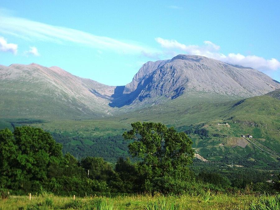
The main path up Britain's highest mountain, from almost sea level in Glen Nevis to a boulder plateau at 1,345 m. Long and stony, with a summit often in cloud.
Watch out: The summit plateau has cliffs and gullies close to the path. In mist, come down on compass bearings (231° then 282°, grid) and count the zigzags.
Planning it for later? Save to Pinterest
It's the highest mountain in Britain, and reaching the summit is a rite of passage for British hikers.
Ben Nevis is the highest mountain in Britain, at 1,345 m, and the Mountain Track is the way most people climb it. It starts almost at sea level in Glen Nevis, just outside Fort William, so you climb nearly the whole height of the mountain in one go: a long, steady path to a lochan halfway up, a stony zigzag climb above it, and a broad summit plateau of boulders with cliffs along its northern edge.
The path is clear and well built, and on a dry summer day it is a long, hard walk rather than a dangerous one. The mountain earns its reputation in cloud, wind and snow, which are common at the top even when the glen is sunny. Coming down the right way off the summit plateau in mist is the one skill this walk really asks of you.
We haven't walked this route ourselves. This guide combines our own measurement of the trail with walking guides and safety advice published between 2022 and 2026. Sources are at the end.
Yes, if you can walk uphill for four or five hours on rough, rocky ground and then come all the way down again, and you can use a map and compass or are going with someone who can.
Think twice if the forecast shows low cloud and strong wind on the tops, or if there's snow on the upper mountain and you don't have an ice axe, crampons and the skills to use them. The West Highland Way finishes in Fort William if you want the scenery without the summit.
| Our measurement | What other guides say | |
|---|---|---|
| Start (Ben Nevis Visitor Centre, Glen Nevis) | about 20 m | |
| Summit | 1,345 m | 1,345 m |
| Distance, one way | 7.9 km | 7.5–8.5 km (15–17 km return) |
| Climb | about 1,320 m | 1,300–1,405 m |
Our line is the Ben Nevis Mountain Path as mapped in OpenStreetMap. The elevation data reads the summit about 20 m low, so the climb above adds that back. Guides give 6 to 10 hours for the return walk; fit, experienced walkers manage it in five or six.
How it goes. From the visitor centre you cross the River Nevis and climb a wide path along the lower slopes of Meall an t-Suidhe, with views across Glen Nevis. The path reaches the Half Way Lochan (Loch Meall an t-Suidhe) on a broad shoulder. At the junction just beyond, go right, cross the gully of the Red Burn, and the climbing starts in earnest: the zigzags, a long series of switchbacks up boulders and scree. Above them, the path crosses the stony summit plateau, marked by cairns, past the heads of Five Finger Gully on your left and Tower Gully and Gardyloo Gully on your right, to the summit cairn, the trig point and the ruins of the old observatory.
| What | Price |
|---|---|
| Walking the Mountain Track | free |
| Ben Nevis Visitor Centre car park | £8 a day, first come, first served |
Looking for another British summit? See Snowdon and Pen y Fan.
Distance and climb come from our own measurement: the Ben Nevis Mountain Path as mapped in OpenStreetMap, sampled against open elevation data (about 30 m resolution). Route details, safety advice and prices come from these pages, checked on 28 October 2026:
Walked it recently and found something different? Tell us and we'll update this page.
Some of these are affiliate links: if you book through them we may earn a small commission, at no extra cost to you. We only list services that fit this trek.
EU 'roam like at home' doesn't apply in United Kingdom, and many plans charge extra there. A Europe data eSIM covers United Kingdom too.
Expect long stretches with no signal on the trail. Download offline maps and our GPX before you start.
Most travel insurance includes hiking at this height. Check that hiking is listed and that medical evacuation is covered.
Rescue is not the same as evacuation. Travel insurance usually pays to fly you to hospital, but not always for the search and rescue itself. Read the policy's "search and rescue" section.
True Traveller sells only to residents of the UK and Europe. Always check the altitude limit and your country of residence in the policy wording. Our trekking insurance guide explains what to look for.
Wild camping is allowed in most of Scotland under the Scottish Outdoor Access Code, if you camp lightly and move on. Parts of Loch Lomond & The Trossachs need a permit from March to September.
Rules change and differ between parks. Check with the local park or tourist office before you pitch a tent.
Measured by us along the OpenStreetMap trail with open elevation data (about 30 m resolution). Expect real figures a few percent higher: maps smooth out small zigzags and bumps, and the highest summits read slightly low.
Map layers load on the live site. Use the overview below meanwhile.
Trail from OpenStreetMap (8.1 km) Start / finish Stop on the way Nearest city
Switch between Topo, Satellite and Street layers with the layer button, and turn on the marked hiking trails overlay. The trail line is the OpenStreetMap hiking route and may differ from the variant you choose. Always carry a proper hiking map on the trail.
Stops: Glen Nevis → Half Way Lochan → Ben Nevis
Best time: July to September (snow can lie on the summit into early summer)
April to May
Often the driest time of year, with long days and fresh green hills. Can still be cold and windy on the tops.
Bring
June to August
Longest days and warmest weather, but also rain showers, busier trails and, in Scotland, midges.
Bring
September to October
Fewer people and beautiful colours, but wetter, windier weather and shorter days.
Bring
Paths can be faint or disappear in mist. Carry an offline map on your phone and a paper map, and know how to use them.
Early in the season, snow can cover the path on high ground. Microspikes or crampons and some experience make these sections safer.
Exposed ridges and summits can be very windy and cold. A windproof layer and hat are worth carrying even on warm days.
5 photos taken on and around the route by Wikimedia Commons photographers. Tap one to see it bigger.
Last updated 29 October 2026. Spotted something out of date? Tell us.
Photo credits: BenNevis by Thincat, Public domain, via Wikimedia Commons; UK-Scotland-Glen Nevis-Steall Waterfall by Toby Thurston, Public domain, via Wikimedia Commons; View near Glen Nevis by Thomas Fabian from Vienna, Austria, CC BY-SA 2.0, via Wikimedia Commons; The summit of Ben Nevis - geograph.org.uk by Peter S, CC BY-SA 2.0, via Wikimedia Commons; Beinn Riabhach in sunlight across Glen Nevis - geograph.org.uk by Peter S, CC BY-SA 2.0, via Wikimedia Commons. Photos resized for the web. Figures are approximate and vary with the variant you choose.


