Getting there
- Flights to Karakol (IKG) 110 km from the start
- Flights to Almaty (ALA) 165 km from the start
Kazakhstan · Nearest city: Almaty
An easy walk down a side canyon of red rock towers to the Sharyn River, in the dry steppe three to four hours east of Almaty.
Watch out: Almost no shade, and up to 45 °C in high summer. Carry plenty of water and walk early.
Planning it for later? Save to Pinterest
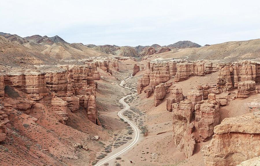
It's Kazakhstan's answer to the Grand Canyon: red rock towers in a canyon carved by the Charyn river.
Charyn Canyon is a gash in the dry steppe east of Almaty, cut by the Sharyn River through red sandstone. The part everyone visits is the Valley of Castles: a side canyon about three kilometres long, lined with rock towers and walls, that you walk down from the rim to the river.
It's a short, easy walk in a remarkable place. The hard part is the journey: three to four hours each way from Almaty, for two or three hours on foot.
We haven't walked this route ourselves. This guide combines our own measurement of the trail with reports from people who visited between 2024 and 2026. Sources are at the end.
Yes, if you want an easy walk with big scenery, you're travelling with children or non-hikers, or you're already heading to the Kolsai Lakes and can stop on the way.
Think twice if you only have one day and dislike long drives, or if it's July or August: the canyon floor has almost no shade and the hottest days are reported at up to 45 °C.
| Our measurement | What other guides say | |
|---|---|---|
| Car park at the visitor centre (rim) | 1,130 m | |
| River at the end of the valley | 950 m | |
| Distance, one way | 2.5 km | 3–4 km |
| Drop on the way in, climb on the way out | 175 m |
Allow about an hour each way, plus time for photos and the river. Our line was drawn by a routing tool along the path mapped in OpenStreetMap, from the visitor centre to the riverbank.
Signs at the rim show where to go down. From there you simply follow the canyon floor between the rock walls until it opens onto the green strip of trees along the river. The walk in is gently downhill. The walk out is the same way in reverse, uphill and usually in the heat of the day.
Weekdays are much quieter than weekends.
Prices reported between 2024 and 2026, in Kazakh tenge. Bring cash: there is no cash machine at the canyon, and cards are rarely accepted at the gate.
| What | Reported price |
|---|---|
| Park entry | about 800–900 tenge per adult |
| Camping | 350 tenge per tent |
| Shuttle between river and car park | about 500 tenge one way |
| Wooden lodge by the river | about 74,000 tenge a night |
| Glamping tent | about 54,000 tenge a night |
| Day tour from Almaty | from about 8,000 tenge |
| Shared taxi Almaty → Kegen road | 2,000–3,000 tenge per seat |
The gate is reported to be open from about 8 am to 7 pm.
Sources disagree about sleeping at the canyon. One 2025 guide lists lodges and glamping tents by the river, bookable by message. Another says the glamping has operated on and off, and a third says there is nothing but camping. If you want a bed, confirm it directly before you leave Almaty. Otherwise bring a tent, or sleep in Saty on the way to Kolsai.
The canyon is about 200 km east of Almaty: three to four hours each way.
Distance and height come from our own measurement: a line routed along the OpenStreetMap path and sampled against open elevation data (about 30 m resolution). Prices, transport and conditions come from these guides, checked in October 2026:
Been there recently and found something different? Tell us and we'll update this page.
Some of these are affiliate links: if you book through them we may earn a small commission, at no extra cost to you. We only list services that fit this trek.
Roaming in Kazakhstan is expensive on most phone plans. A data eSIM bought before you fly gets you online as soon as you land.
Expect long stretches with no signal on the trail. Download offline maps and our GPX before you start.
Most travel insurance includes hiking at this height. Check that hiking is listed and that medical evacuation is covered.
Rescue is not the same as evacuation. Travel insurance usually pays to fly you to hospital, but not always for the search and rescue itself. Read the policy's "search and rescue" section.
True Traveller sells only to residents of the UK and Europe. Always check the altitude limit and your country of residence in the policy wording. Our trekking insurance guide explains what to look for.
Camping is allowed in many areas of the national parks at designated spots, sometimes with a small fee. Border zones need a permit.
Rules change and differ between parks. Check with the local park or tourist office before you pitch a tent.
Measured by us along the OpenStreetMap trail with open elevation data (about 30 m resolution). Expect real figures a few percent higher: maps smooth out small zigzags and bumps, and the highest summits read slightly low.
Map layers load on the live site. Use the overview below meanwhile.
Trail routed along OpenStreetMap paths (2.6 km) Start / finish Stop on the way Nearest city
Switch between Topo, Satellite and Street layers with the layer button, and turn on the marked hiking trails overlay. The trail line is the OpenStreetMap hiking route and may differ from the variant you choose. Always carry a proper hiking map on the trail.
Stops: Charyn Canyon visitor centre → Sharyn River
Best time: April to June, September to October
June to early July
Snow still on high passes, fast rivers from snowmelt and green pastures filling with herders.
Bring
Mid-July to August
The best weather window, but high passes can still get snow and storms.
Bring
September
Clear skies and autumn colours, with freezing nights and herders leaving the high pastures.
Bring
Start at dawn, rest in the shade at midday, and carry more water than you think. Electrolytes help.
5 photos taken on and around the route by Wikimedia Commons photographers. Tap one to see it bigger.
Last updated 29 October 2026. Spotted something out of date? Tell us.
Photo credits: Charyn Canyon, Kazakhstan by Bgag, CC0, via Wikimedia Commons; Charyn Canyon, Kazakhstan by Bgag, CC0, via Wikimedia Commons; Raiymbek District, Kazakhstan - panoramio by Anton Yefimov, CC BY 3.0, via Wikimedia Commons; Charyn Canyon, Kazakhstan by Bgag, CC0, via Wikimedia Commons; Valley of castles - panoramio by dmccarhty, CC BY-SA 3.0, via Wikimedia Commons. Photos resized for the web. Figures are approximate and vary with the variant you choose.


