Getting there
- Flights to Sofia (SOF) 50 km from the start
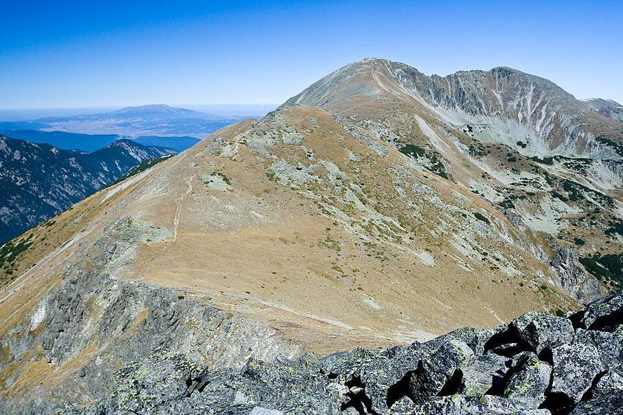
The highest peak in the Balkans, reached from the top of the Borovets gondola by a clear path past two huts and a chain of high lakes.
Watch out: Summer storms build quickly, and the last gondola down leaves at about 6 pm. Set a turn-round time.
Planning it for later? Save to Pinterest
It's the highest peak in the Balkans and the easiest 2,900 m summit in Europe thanks to a gondola.
Musala (2,925 m) is the highest mountain in Bulgaria and on the whole Balkan Peninsula, a few metres higher than Olympus. It is also one of the easiest "highest peaks" in Europe to reach. A gondola from the ski resort of Borovets lifts you to 2,369 m, and a clear path leads on past two huts and a chain of lakes to the top.
The normal summer path is not technical. What catches people out is the height, the weather and the last gondola down.
We haven't walked this route ourselves. This guide combines our own measurement of the trail with reports from people who walked it between 2024 and 2026. Sources are at the end.
Yes, if you can walk six to seven hours on stony ground and want a real summit without technical difficulty.
Think twice if you've come straight from sea level and feel altitude easily: you spend the whole day between 2,350 and 2,925 m. And don't plan it for a Monday or Tuesday, when the gondola is reported closed.
We measured the normal route from the top of the Yastrebets gondola.
| Our measurement | What other guides say | |
|---|---|---|
| Top of the gondola | 2,350 m | 2,369 m |
| Summit | 2,925 m | 2,925 m |
| Distance, one way | 6.5 km | about 7 km |
| Climb | about 590 m | about 570 m |
Open elevation data smooths the summit by about 65 m; we've added that back to the climb.
Reported times: 3 to 4 hours up and 2.5 to 3 hours down, so about 7 hours in all with breaks. The day comes in three parts:
Start early. Afternoon cloud and thunderstorms are common, and the summit is the last place to be in one.
Prices and times reported in 2025 and 2026:
| What | Reported |
|---|---|
| Gondola, adult return | about €19 |
| Gondola, child (7–13) | about €11 |
| Ride time | about 25 minutes each way |
| Running days in summer | Wednesday to Sunday |
| Hours | 8.30 am to 6 pm; last ride up 5.30 pm, last ride down 6 pm |
| Bed at the Musala hut or the Icy Lake shelter | about €20 |
The resort has in past summers started the gondola at 8 am at weekends from late July. Summer days, hours and prices change from year to year, so check the Borovets resort page (linked on this page) the day before. Winter ski tickets cost about twice as much; don't be put off if that's the price you find first.
Both are basic mountain huts. There is a weather station on the summit, where hot tea is usually on sale.
Borovets is about 73 km from Sofia: an hour and a quarter by car.
By public transport, buses leave Sofia's South bus station (Avtogara Yug) for Samokov about every half hour through the day. The fare was reported at 6 to 8 leva in 2025, which is €3 to €4. From Samokov a minibus covers the last 15 km to Borovets in about 20 minutes. Leave Sofia on one of the first buses if you want to be up and down in a day; a night in Borovets makes it far more relaxed.
Distance and climb come from our own measurement: a line routed along OpenStreetMap paths and sampled against open elevation data (about 30 m resolution), corrected at the summit as explained above. Prices, timetables and conditions come from these sources, checked in October 2026:
Walked it recently and found something different? Tell us and we'll update this page.
Some of these are affiliate links: if you book through them we may earn a small commission, at no extra cost to you. We only list services that fit this trek.
Phone plans from the EU and EEA roam here at home prices. Coming from the US, UK or elsewhere? A Europe data eSIM is usually far cheaper than roaming.
Expect long stretches with no signal on the trail. Download offline maps and our GPX before you start.
This trek reaches 2,925 m. The policies below include hiking on marked routes to at least 3,000 m without an upgrade: World Nomads for UK residents and True Traveller to 3,000 m, SafetyWing's Nomad Insurance to 4,500 m, and World Nomads for US residents to 6,000 m. Limits differ by country of residence, so check yours.
Rescue is not the same as evacuation. Travel insurance usually pays to fly you to hospital, but not always for the search and rescue itself. Read the policy's "search and rescue" section.
True Traveller sells only to residents of the UK and Europe. Always check the altitude limit and your country of residence in the policy wording. Our trekking insurance guide explains what to look for.
Camping is restricted in national parks. Use the mountain huts (hizhas).
Rules change and differ between parks. Check with the local park or tourist office before you pitch a tent.
Measured by us along the OpenStreetMap trail with open elevation data (about 30 m resolution). Expect real figures a few percent higher: maps smooth out small zigzags and bumps, and the highest summits read slightly low.
Map layers load on the live site. Use the overview below meanwhile.
Trail routed along OpenStreetMap paths (6.7 km) Route variant Start / finish Stop on the way Nearest city
Switch between Topo, Satellite and Street layers with the layer button, and turn on the marked hiking trails overlay. The trail line is the OpenStreetMap hiking route and may differ from the variant you choose. Always carry a proper hiking map on the trail.
Stops: Yastrebets gondola top → Musala hut → Musala
Best time: July to September
June to early July
Snow patches linger on north-facing slopes and high passes. Huts are just opening, meadows are full of flowers and paths are quieter.
Bring
Mid-July to August
Most reliable weather, but also the busiest huts and frequent afternoon thunderstorms. Hot in the valleys.
Bring
September
Clear, stable days and fewer people, but shorter daylight, cold nights and some huts closing mid to late September.
Bring
Thunderstorms often build after midday in summer. Start early, cross passes and summits before noon, and never shelter under lone trees or on ridges.
You'll feel the altitude on the climbs. Spend a night or two in the mountains first if you can, and pace yourself.
5 photos taken on and around the route by Wikimedia Commons photographers. Tap one to see it bigger.
Last updated 29 October 2026. Spotted something out of date? Tell us.
Photo credits: Musala by Deyan Vasilev ( Dido3 ), CC BY-SA 3.0, via Wikimedia Commons; The Rila Hotel Facade by Marketingrilaborovets, CC BY-SA 4.0, via Wikimedia Commons; Боровец, . . - panoramio by Nikolai Karaneschev, CC BY 3.0, via Wikimedia Commons; Леденото езеро by DanailVasilev, CC BY-SA 4.0, via Wikimedia Commons; Изглед към Мусала by DanailVasilev, CC BY-SA 4.0, via Wikimedia Commons. Photos resized for the web. Figures are approximate and vary with the variant you choose.


