Getting there
- Flights to Bishkek (BSZ) 120 km from the start
Kyrgyzstan · Nearest city: Bishkek (also Kochkor)
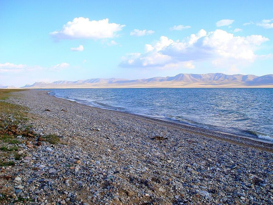
A walk or horse trek over high pastures to Song-Kul, a lake at 3,016 m where herders set up yurt camps each summer.
Watch out: Nights are cold even in July. Yurt camps are basic; bring a warm layer and cash.
Planning it for later? Save to Pinterest
It's a chance to live with nomadic herders in yurts beside a high mountain lake.
Song-Kul is a wide, shallow lake at 3,016 m in the middle of Kyrgyzstan, ringed by summer pastures. From June to September herding families move up with their horses and sheep and put up yurts along the shore, and travellers come to stay with them. You can drive there. Walking or riding in from Kyzart takes two days and gives the lake a proper arrival: you come over a pass and it is suddenly all below you.
This is the gentlest multi-day trek we cover in Central Asia. There is no scree, no technical ground and no single huge climb. What makes it serious is the height you sleep at and how fast the weather turns.
We haven't walked this route ourselves. This guide combines our own measurement of the route with reports from people who walked or rode it between 2024 and 2026. Sources are at the end.
Yes, if you want a first trek in Kyrgyzstan, you'd like to try a horse trek, or you care more about life on the pastures than about summits.
Think twice if you want dramatic, rocky mountains (go to Ala-Kul instead) or if you sleep badly at altitude: the yurts on the shore are above 3,000 m.
We measured the classic way in from Kyzart village along paths mapped in OpenStreetMap.
| Day | From → to | Distance | Climb | Descent | Highest point |
|---|---|---|---|---|---|
| 1 | Kyzart → Kilemche pastures | 21 km | 560 m | 100 m | 2,610 m |
| 2 | Kilemche → Jalgyz-Karagai pass → Song-Kul | 14 km | 750 m | 330 m | ≈ 3,300 m |
That's about 35 km and 1,300 m of climbing to reach the lake. Sources give the pass as 3,325 m to 3,400 m; our line tops out a little lower, at about 3,260 m, because open elevation data smooths the ridge.
Our trail line here was drawn by a routing tool along mapped paths between Kyzart, the Kilemche camp, the pass and the shore. The pastures are open, and herders and horses take many parallel paths, so treat it as a good guide rather than the one true line.
Two days in, then out by car (simplest). Walk or ride to the lake as above, stay a night or two, and take a pre-arranged car out to Kochkor.
Three days, back to Kyzart. Most horse treks return to Kyzart on the third day by a different pass, so you never retrace your steps. The Tuz-Ashuu pass (3,228 m) route between the lake and Kyzart is about 27 km.
One long day. Fit walkers can go from Kyzart to the lake over the Tuz-Ashuu pass in a day: about 27 km with 740 m of climbing.
On foot or on horseback? Both follow the same paths. A horse turns two walking days into two easy days of four to five hours in the saddle, and no riding experience is needed: a horseman leads the group. Walkers often hire a horse just to carry the bags.
Prices are what travellers reported in 2025 and 2026. Everything is cash.
| What | Reported price |
|---|---|
| Yurt camp with dinner and breakfast | about €25 per person |
| Horse, per day | from about $30 |
| Horseman or guide, per day | about $30 |
| Three-day horse trek arranged in Kyzart | about 10,000–13,000 som per person in a group; around 20,000 som if you're alone |
| Fully arranged three-day tour booked in advance | often $500 or more per person |
| Shared taxi Kochkor → Kyzart | about 500 som per seat; 2,000–3,000 som for the car |
Arranging the trek in Kyzart on arrival is much cheaper than booking a package from abroad, and in July and August there are always horses and guides available. Community tourism offices in Kochkor and Bishkek can also set it up; reports say they cost a little more.
There are yurt camps at Kilemche for the first night and many along the north shore of the lake. Yurts are heated with a stove, and beds are thick quilts on the floor. Toilets are basic and outdoors.
Kyzart is reached through the town of Kochkor, on the road from Bishkek to Naryn. From Kochkor a shared taxi takes about an hour and a half to Kyzart. The airport most people use is listed in the Before you go box on this page.
To leave the lake without walking back, arrange a car through your yurt camp or guide before you set off: there is no public transport at the lake.
Distances and climbs come from our own measurement: a line routed along OpenStreetMap paths, sampled against open elevation data (about 30 m resolution). Prices, transport and conditions come from these guides, checked in October 2026:
Been there recently and found something different? Tell us and we'll update this page.
The classic walk in from Kyzart: one day over a low pass to the Kilemche pastures, one day over the Jalgyz-Karagai pass to the lake. Most people ride or walk back to Kyzart by a different pass on a third day, or leave by car.
Over a first pass into a wide, green valley dotted with herders' yurts.
Sleep: Yurt camp at Kilemche
A steady climb to the Jalgyz-Karagai pass, then down to the lake.
Sleep: Yurt camp on the lake shore
Day 2, from the Jalgyz-Karagai pass, when the whole lake appears below you.
The lake shore itself: a spare day for riding, walking the shore and watching the herders' summer life.
Some of these are affiliate links: if you book through them we may earn a small commission, at no extra cost to you. We only list services that fit this trek.
Roaming in Kyrgyzstan is expensive on most phone plans. A data eSIM bought before you fly gets you online as soon as you land.
Expect long stretches with no signal on the trail. Download offline maps and our GPX before you start.
This trek reaches 3,300 m, above the 3,000 m that World Nomads (for UK residents) and True Traveller include as standard: you need World Nomads' Level 2 upgrade (to 4,500 m) or True Traveller's Adventure pack (to 4,600 m). SafetyWing's Nomad Insurance covers hiking on official paths up to 4,500 m, and World Nomads' US Standard plan up to 6,000 m.
Rescue is not the same as evacuation. Travel insurance usually pays to fly you to hospital, but not always for the search and rescue itself. Read the policy's "search and rescue" section.
True Traveller sells only to residents of the UK and Europe. Always check the altitude limit and your country of residence in the policy wording. Our trekking insurance guide explains what to look for.
Yurt camps at Kilemche and along the lake shore offer a bed, dinner and breakfast in summer. You can also pitch a tent almost anywhere on the pastures; ask the nearest family.
Rules change and differ between parks. Check with the local park or tourist office before you pitch a tent.
| Day | Stage | Distance | Climb | Descent | Highest |
|---|---|---|---|---|---|
| 1 | Kyzart → Kilemche | 21.0 km | 564 m | 104 m | 2,608 m |
| 2 | Kilemche → Song-Kul | 14.3 km | 752 m | 325 m | 3,264 m |
Measured by us along the OpenStreetMap trail with open elevation data (about 30 m resolution). Expect real figures a few percent higher: maps smooth out small zigzags and bumps, and the highest summits read slightly low.
Map layers load on the live site. Use the overview below meanwhile.
Trail routed along OpenStreetMap paths (35.5 km) One colour per day Start / finish Stop on the way Nearest city
Switch between Topo, Satellite and Street layers with the layer button, and turn on the marked hiking trails overlay. The trail line is the OpenStreetMap hiking route and may differ from the variant you choose. Always carry a proper hiking map on the trail.
Stops: Kyzart → Song-Köl
Best time: June to September
June to early July
Snow still on high passes, fast rivers from snowmelt and green pastures filling with herders.
Bring
Mid-July to August
The best weather window, but high passes can still get snow and storms.
Bring
September
Clear skies and autumn colours, with freezing nights and herders leaving the high pastures.
Bring
You'll feel the altitude on the climbs. Spend a night or two in the mountains first if you can, and pace yourself.
Nights can be near freezing even in summer. A warm sleeping bag and dry base layers make a big difference.
4 photos taken on and around the route by Wikimedia Commons photographers. Tap one to see it bigger.
Last updated 29 October 2026. Spotted something out of date? Tell us.
Photo credits: Song-Köl by Ondřej Žváček, CC BY 2.5, via Wikimedia Commons; Song-Kul, Kyrgyzstan by Oziel Gómez ozgomz, CC0, via Wikimedia Commons; Song Köl lake, Kyrgizstan by Thomas Depenbusch (Depi) from Cologne, Germany, CC BY 2.0, via Wikimedia Commons; Viwew to Ak-Tash mountains, Son-Kul, Kyrgyzstan - panoramio by ThomasG, CC BY-SA 3.0, via Wikimedia Commons. Photos resized for the web. Figures are approximate and vary with the variant you choose.


